Regarding the census and the development of a Geographic Information System, what is sought is to know is:
- Number of trees and species that each municipality has,
- Treatments performed (phytosanitary, pruning, planting/ replanting, etc.),
- Number of trees risky for civil safety,
- Diagnosis in terms of planting sites and irrigation system (ditches)
It can be said that this census will generate a new mode of management in the management of urban trees in each of the municipalities and provincial organisms with inherence in the subject.
A very special service will be obtained that does not consist of a simple tree count – as could be interpreted with the common meaning of the word “census” – but an advanced application based on a georeferenced survey on constant data refresh is requested.
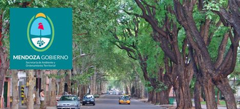
The entire existing road forest mass of the seven metropolitan area departments will be registered in the summer of 2020/2021 digitally, with LIDAR technology and 360-degree cameras. The digital platform that will host the data will be available to the municipalities to organize its maintenance, the Directory of Natural Resources to control its evolution and also of each of the citizens to know what species it has in the front of its house and other useful data on the management of urban trees.
It is an instrument that will allow decisions to be made to save monetary resources and energy: at the metropolitan scale, it means reducing spending on high amounts of money. Forestry around buildings filters out warm air and refreshes it, by shading, significantly reduce the use of air conditioning.
Activities to develop
Activity 1: Survey Strategy
- Survey Strategy
Activity 2: Analysis and Design
- Analysis and Design Reports
Activity 3: Census Urban Road Tree
- Maipú and Godoy Cruz Survey Report
- Guaymallen, Las Heras and Lavalle Survey Report
- Survey Report Lujan de Cuyo, Mendoza City, Integrative Report
Activity 4: GiS Development and Implementation
- Development of the Geographic Information System (prototype version)
- Installation and Operational Testing
- Start of Production
Activity 5: Provision and Treatment of Remote Sensing Material
- Provision and processing of images (POI)
Activity 6: Determination of the Area of Tree Coverage
- Vectorization of the tree surface
Activity 7: Training according to the level of Users
- Training Report